Fig. 3.
Download original image
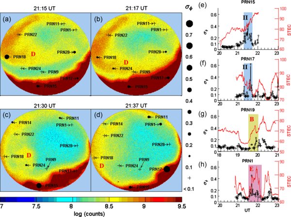
The same format as Figure 2. (a–d) Patch D moved southward and entered into the auroral zone (red colored regions) to become into an auroral blob. Phase scintillations were intensified when patch D passed through the LOS of GPS satellites. (e, f) The shaded regions correspond to the time period when the newly formed blob passed through the LOS of PRN15 and PRN17. There is no data after 22:00 UT in (e) and before 20:54 UT in (f) because PRN15 and PRN17 were out of the FOV at that time. (g, h) The shaded regions correspond to the time periods when patches B and E passed through the LOS of PRN19 and PRN1, respectively. PRN1 was out of the FOV before 20:49 UT and no data was recorded for that time in (h).
Current usage metrics show cumulative count of Article Views (full-text article views including HTML views, PDF and ePub downloads, according to the available data) and Abstracts Views on Vision4Press platform.
Data correspond to usage on the plateform after 2015. The current usage metrics is available 48-96 hours after online publication and is updated daily on week days.
Initial download of the metrics may take a while.